Xinjiang, as the backbone of asia, has received extensive attention and discussion, and a number of committed men have tried to resolve the drought in xinjiang. This paper analyses the causes of drought in xinjiang in terms of topography, water flow, water and soil characteristics for the benefit of friends。
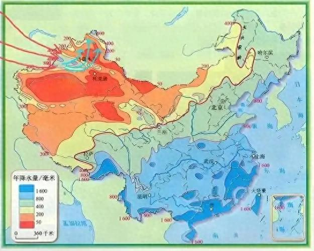
Figure 1 status of water resources in xinjiang
I. Closing the fields contained in the outside water
The xinjiang border is located in the interior of asia and europe, surrounded by three mountain ranges: tianshan, kunlun and altai, forming a typical “three mountains in two basins” (baygar basin, tarrywood basin)。
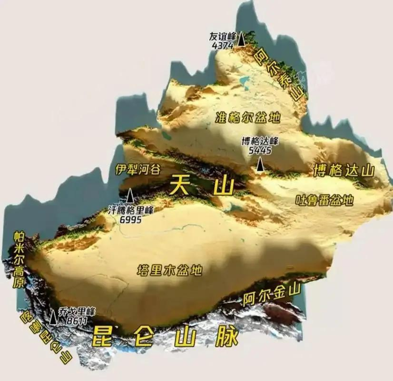
Figure 1
This terrain leads to:
Water and steam passage block:
The western wind belt carries atlantic water gas that cuts across europe and central asia, leaving less than 5 per cent of the wet gas flow after a long run to xinjiang; the indian ocean and pacific water vapours are completely blocked by the tibetan plateau, mount kiran-alkin, and the water flows are not forthcoming。
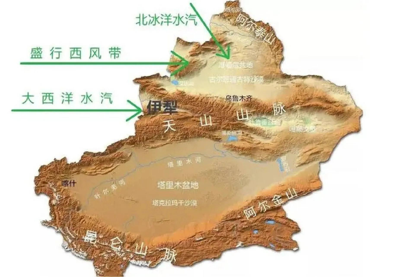
Figure 3 atlantic water vapour is blocked by the tianshan mountains
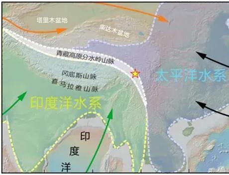
Figure 4 indian ocean water vapour is cut off by the tibetan plateau and pacific water vapour is cut off by mount kiran-alkin
The effect of the rain has increased:
The northern slope of the tianshan mountains can be precipitation up to 600-800 mm per year, while the tari wood basin on the southern slope is only 50-100 mm, resulting in extreme drought due to the effects of the rain。
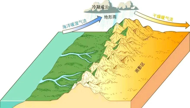
Figure 5
Altitude gradient limits, with no rainfall of internal water:
Intra-basin elevations of about 500 to 1,500 metres are difficult to produce effective precipitation, and evaporated water is not able to return to the ground。
Ii. Deep in the interior causes deep water scarcity
Xinjiang has a very limited source and transport path:
1 atlantic water is the end of the crossbow:
When atlantic water is transported 5,000 kilometres to xinjiang, the amount of water is less than 1 per cent, and only limited precipitation at the edge of the ghar basin is maintained。
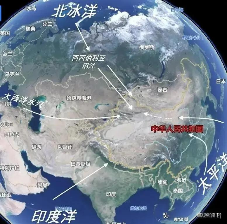
Figure 6 last tear of atlantic water vapour
2 pacific water gas is too long:
In the summer south-east monsoon, which affects the western corridor of the gansu river as far as possible, pacific water vapours are unable to climb over mount kiran-alkin
The south-west monsoon was completely isolated from the tibetan plateau and xinjiang became a monsoon blind zone。
The 3-spot circulation is a battle between the trapped animals and does not produce rainfall:
The evaporation of water vapours within the basin (on average about 2000-3000 mm per year) makes it difficult to form efficient precipitation due to mountain-free lifts, and more than 90 per cent cannot be re-entered。
[the message is that the water that is delivered to xinjiang can only be used once, requires precision to enter the door, precision to root, to reduce evaporation and leakage, and that the water lost is no longer available because it cannot form rainfall]
Iii. Field-less responsibility
The total amount of water resources in xinjiang is approximately 83. 2 billion cubic metres per year, but there are serious structural contradictions:
One ice-melted water
About 70 per cent of the river run-off is dependent on high-mountain ice melts, of which 80 per cent of the river tariwood is digested by glaciers。
2 seasonal distribution imbalance
High summer temperatures (june-august) cause run-off to account for 60-80 per cent of the year, while the peak water demand for agriculture in the spring is only 10-15 per cent, leading to a high incidence of spring drought and failure to complete planting. This requires the establishment of mountain reservoirs to save summer runoff for use during spring farming。
3 spatially unevenly distributed
Water resources are concentrated in mountain areas, which account for 6 per cent of the national territory, while 90 per cent of oasis and arable land are located on the edge of the basin, with long distances and high losses. This requires the establishment of a pipeline network to channel mountain water resources to the edge of the basin for industrial and agricultural use。
Iv. The double siege of evaporation and salinization
The xinjiang soil is shaped by the arid climate and presents a unique dilemma:
1 low organic matter and high evaporation
The organic content of desert soils is only 0. 1-0. 6 per cent, and water holding capacity is extremely weak; average annual evaporation is as high as 2000-3000 mm, with less than 5 per cent precipitation seepage。
2 salinization
The closed terrain of the basin has resulted in a lack of salinity, with 30 per cent of the arable land affected by salinization, and surface soils containing up to 2-5 per cent salt (the crop tolerance limit is usually 0. 3 per cent)。
It's severe weather erosion
The takrama dry desert covers an area of 330,000 square kilometres, each year advancing 5-10 metres towards oasis, further reducing water conservation capacity following the erosion of soil fine particles。
Conclusion: systemic thinking for drought resolution
The drought in xinjiang is the result of the combined effect of terrain barrier, climate evaporation and soil leakage. The future will require:
1. Optimization of ice and snow resources: construction of high mountain reservoirs and water pipeline networks to improve the capacity for water management
2. The soil improvement revolution: promotion of biocarbons to improve sand saline lands and improve water conservation
3. Upgrading water conservation technologies: increasing the prevalence of drip irrigation and significant water savings in agriculture
4. Ecological barrier construction: planting drought-resistant vegetation along the edges of the desert to reduce wind erosion。
This is the only way to break the shackles of drought and awaken the oasis of the west。