In october, it was supposed to be an autumn season. This year, however, in kim autumn, our weather in the north and south of the country was marked by a double-flash of ice。
On 10 october, at 1000 hours, the central weather station continued to issue a blue warning of heavy rains, which are expected to occur in parts of the north-west sichuan basin, central and south-west sichuan basin, south-west of the mountains and south of the river. At the same time, high temperatures still prevail in the main parts of gangnam and the north of china. Some of these areas have a high temperature of over 38°c。
Yesterday, the highest temperature in the south suburbs of beijing was only 10. 6°c, the lowest in the same period in 74 years, with temperatures in the north cooling out from mid-november. During the national holiday, south of the yangtze river experienced “the hottest mid-fall ever”. When will the situation end: "you're in the north, i'm in the south, i'm in the south?" why is it all of a sudden, in the fall that we know
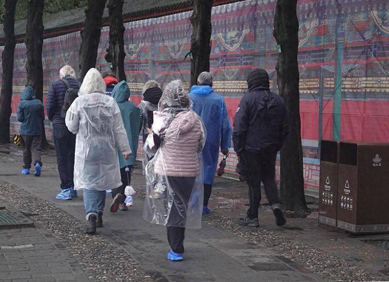
On 9 october 2025, visitors from beijing and the middle and outside the park went on a winter tour. Figure / visual china
"was it cold, warm" or more frequently
“it is true that in the early part of october this year, the number of regional storm surges in the northern region was significantly higher than during the same period of the year.” in an interview with china news weekly, the head of the meteorological disaster risk management unit of the national climate centre, the kingdom, stated that, between 1991 and 2020, in mid-october of 30 years, there had been six regional violent rains, averaging 0. 2 times a year. In the first half of october this year, there were two regional sex storms in the northern part of the country. Of these, on 9 october, the cumulative average precipitation in the north-west, shanxi and kyingjin belts reached 25-100 mm and the local area exceeded 100 mm。
Many of the experts interviewed analysed the recent increase in precipitation in the north as a result of the continued stabilization of the yangtze and gangnam areas in the western pacific ocean under sub-tropical pressure (hereinafter referred to as “sub-high”). More graphically, sub-highs are like a huge “heating hood” in which the region of the south is covered by warm and dry conditions. The sub-highs in the south are “sustained” to form a “water and gas conveyor belt” that keeps moving the sources of warm and wet water from the sea to the north, where they meet with cold air in the south, creating a continuous autumn rain. Thus, the seemingly opposite weather in the north and the south is in fact two sides of this “coin”。
According to xu xiao feng, a researcher from the china meteorological administration and the china meteorological service association, when they entered the autumn, the deputy high was supposed to leave southward, but in comparison with the same period of the year, its position was abnormally northward and extremely strong. The kingdom again believes that so “obstinate” is the result of a combination of multiple factors. On the one hand, global warming has led to a long-term increase in sub-highs and a gradual expansion of the impact northwards; on the other hand, phenomena such as la niña have changed the temperature of sea water and further contributed to the sub-higher anomalies. At the same time, the cold air in the north is weak and fails to form an effective deterrent, thus opening the door to sub-highness。
Active typhoons also formed a barrier that prevented secondary heights from moving south. The chinese academy of sciences institute of atmospheric physics, researcher wei ko, explained to china newsweek that the general circulation system is a closely interrelated whole and that the various parts of the system interacted with each other, “from september to early october this year, exceptionally active typhoons in the south china sea and south china, such as `gaza ' , `boroy ' , have had a direct impact on deputy go nam's retreat”。
According to xu xiao feng, the current pattern of north-south climate polarization in our country, although unexpected to the public, is “foreseeable” in climate science. He explained that global warming had led to increased atmospheric volatility, which meant that events such as extreme droughts and precipitation would also fluctuate in terms of time and spatial distribution, and that “the cold will not be cold, the warm will not be warm” would be more frequent. It was emphasized that this trend is not limited to my country, and the continued rise in global average temperatures shows that extreme weather has become a serious global common problem。
China's climate change blue book (2025), published by the china meteorological administration, shows that the incidence of extreme high temperatures and heavy precipitation has continued to increase since 1961, with our climate risk index reaching a record high in 2024. Several of the experts interviewed stated that, as global warming continued to increase, sub-highs increased exceptionally, and trends in west stretch and north lifts occurred in the future or more frequently. The kingdom reiterates its belief that, in the coming decades, heat and heavy rains will become more frequent. In particular, jiangnan and south china may face more frequent high-temperature heat waves and more intense rainfall processes in the north。
When will the high temperatures in the south be reduced
When will this wet and cold autumn rain in the north end? The kingdom reverts to the china news weekly, saying that by 13, medium-to-large rains are expected to continue in parts of the eastern north-western region, north-western china, and huang huai. “but it is expected that the northern region will gradually return to warming and return to normal temperatures throughout the year.”
By contrast, the forces of the “autumn tigers” in the south appear to be more stubborn. The kingdom recalls that, due to the exceptional strength and stability of the deputy highs, it is expected that over the next three or four days there will be high temperatures above 35°c in jiangxi, zhejiang, fujian, the north-central guangdong, north-eastern guangxi and hunan. Among them, jiangxi and its surroundings have the strongest temperatures, and the highest temperatures are likely to reach 37-39°c in the eastern part of hunan, the north-central part of the river and the west-central part of the zhejiang river. The kingdom further indicated that according to the national climate centre, there would be a small amount of cold air south from 13 to 15 days and that high temperatures in the south would be slightly reduced from 14 to 15 days, but not completely reduced. It is expected that a moderate cold air process will affect the country from 21 to 23 march, when the southern “autumn tiger” is expected to be completely relieved。

On 1 october 2025, tourists from the chang college neighbourhood in jiangxi. Figure / visual china
The kingdom reiterates that the climate patterns of “hot, dry south” will pose significant challenges to our agricultural production, the ecological environment and public health. The persistence of low-temperature rainfall in the north may lead to crop losses, frequent pests and diseases, which directly threaten food security, while in the south, high-temperature droughts and pressures such as widespread crop damage and drying up of irrigation water sources can seriously threaten the ecological balance by rapidly increasing levels of forest fire in some areas. At the same time, this climate pattern poses a serious challenge to public health: the wet and cold environment in the north is prone to respiratory and rheumatological diseases, while the continued high temperature in the south can significantly increase the risk of heat and cardiovascular disease, directly threatening public health。
Several of the experts interviewed highlighted the recent low body temperature in the north, which allowed the public to respond flexibly to temperature changes by using the “onion” three-tier dress, i. E., internal sweating, mid-level regulation, and outer wind protection. The elderly, children and the infirm are particularly sensitive to the need for protection and, when necessary, for heating equipment to be turned on, except for wetting and heating, and to avoid prolonged stay in a wet and cold environment outside the home. In the south, where high temperatures persist in many places, the public should avoid long periods of outdoor activity during periods of high temperatures, with sunscreening and timely water recharge. Whether in the north or the south, the public should pay close attention to weather forecasts, adjust travel and clothing in a timely manner, and take appropriate precautions to address the multiple challenges posed by the current abnormal climate in the event of any discomfort。
Intern: liu zyon