Using cad tectonic lines, you can create tectonic lines (radio) that extend indefinitely to one end, or
An infinite extension of a tectonic line (reference line) at both ends. You can also create circular tectonic lines。
Implementation modalities:
(1) menu bar: drawing the construction line
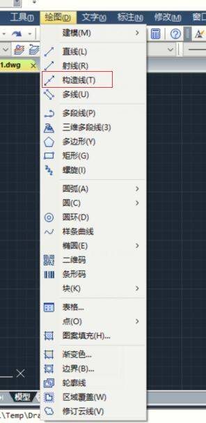
(2) drawing function area: drawing to construct line button
(3) shortcut: xl
2. Methods of use
(1) the substance of the tectonic line is a straight line extending at both ends without a wire, so that the tectonic line follows the principle of establishing a straight line at two points。
(2) horizontal and vertical tectonic lines
Method i: start a positive or polar axis tracking
Opens a straight turn, by one point drawing only a horizontal and vertical tectonic line。
The polar axle tracking is activated, and through one point numerous tectonic lines can be drawn, but there is only one horizontal and vertical tectonic line。
If a group of horizontal and vertical tectonic lines is required, the active and polar axis tracking is required。
Method ii: secondary command for construction lines
Horizontal
Vertical
(3) drawing of tectonic lines determined by angle: angle (a)
The angles here are the angles with the angles of the x-axis。
(4) tectonic line drawing an angle diagonal line: 2nd (b)
The tectonic line in the figure is the arc of this straight angle。
(5) offset (o)
The shift distance of 30 is the vertical distance between the line and the construction line。
The cad tectonic line does not change the extension of the project map, and therefore their unlimited dimensions do not affect the scaling or visualization. Users can move, rotate and copy tectonic lines like other objects. A tectonic line can be used as a reference for creating other objects. For example, a user can use a tectonic line to find a central point for perforation, prepare multiple views for the same object, or create temporary cross-sections that can be used for object capture。