In the knowledge systems of advanced geology, climate will always be a central consideration. It combines topography, hydrology, vegetation, agriculture, cities and human activities and is an important vehicle for integrated geographic thinking. Each detail hides a myth from the basics of temperature, precipitation, to the interpretation and distribution of climate types, to the profound impact of climate on regional development. Today, together, we have prepared the core of the climate in the high-level examination, and we have done everything we can to help prepare for it with efficiency and precision。
I. Methodologies for determining climate types
(1) “as a soft ball” - the southern and northern hemispheres are judged by the month in which the highest (or lowest) temperature occurs。
(2) “tramp belt” - the temperature band is determined on the basis of the average monthly temperature of the coldest or hottest month。
(3) `water-stereotyped' - the climate type (annual rain type, summer rain type, winter rain type, low rainfall type) is determined on the basis of annual precipitation and seasonal distribution。
Tropical climate
Coldest month
> 15 °c
All year long, 2000 mm
Tropical rainforest climate
It's clear in the dry and wet season, 750-1000 mm
Tropical savanna climate
Two seasons of drought and rain, >1,500 mm
Tropical monsoon climate
There is little rainfall all year round,
Tropical desert climate
Subtropical
Climate
Coldest month
> 0 °c
Rainfall winter, 300-1000 mm
Mediterranean climate
Rain fever for the same period, 800-1500 mm
Subtropical monsoon climate
Temperature climate
Coldest month
> 0 °c
Wet throughout the year, 700-1000 mm
Temperature marine climate
Coldest month
Rain fever for the same period, 500-800 mm
Temperature monsoon climate
There is little rainfall all year round,
Temperature continental climate
Ii. Climate characterization techniques
(1) the description of climate characteristics captures three core points:
First, the type of climate is indicated and then the elements of temperature and precipitation are described separately。
The description of temperature indicates high and low temperatures in the winter and summer, poor temperatures in the day and years, and common terms such as hot or cool, cold or mild。
The description of precipitation indicates the amount of precipitation in the winter and summer, the size of annual precipitation and seasonal variations in precipitation, and the size of seasonal variations in terms commonly used for rainfall or less, wet or dry, and precipitation。
(2) the description of climate distribution captures two positions: latitude and surface. For example, the climate of the mediterranean is spread in the west bank, in the south, in the north, at 30°-40° latitude, in the subtropical monsoon, on the east coast of the south, in the north, at 25°-35° latitude, etc。
(3) the description of the causes of climate change begins mainly with atmospheric circulation, land and sea positions, topography, ocean currents, etc。
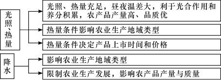
(4) exploring the impact of climate on agriculture, often describing temperature differentials, strong and weak light, heat and precipitation。
Impact of climate on natural geography
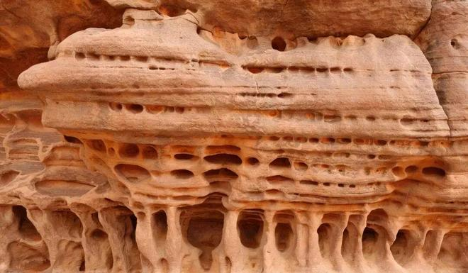
(1) the geomorphology (e. G. Erosion of precipitation to the surface, winding of rocks with high temperature differentials between day and night)

(2) effects on water bodies
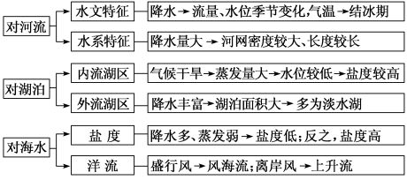
(3) impact on snowlines
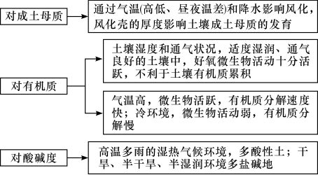
(4) soil effects
(5) effects on organisms
Climate affects the geographical distribution of flora and fauna. What kind of climate does it have? Different organisms adapt to different habitats and form different population sizes。
Distribution of climate and vegetation types (level distribution, vertical distribution), growth and development of vegetation; temperature and animal migration (redeer and bird migration, fish migration, shifting rangers)。
Wind sizes also affect plant formations, with small, flag crowns being planted in areas with high wind。
Climate impacts on human production and life
(1) impact on agricultural production
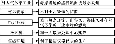
(2) impact on industrial layout
(3) impact on transport
Impacts on inland water transport: inland water shipping is affected by affecting water levels, volumes and ice periods of rivers。
2 impacts on oceanic shipping: effects such as wind and counterwind, typhoons and hurricanes。
3 impacts on aviation: effects of severe weather, such as fog weather, wind and heavy rains。
4 impact on pipeline transport: effects of cryogenic freezing。
5 impacts on road and rail transport: effects of catastrophic weather — typhoons, cold tides (high winds, cooling, freezing), heavy rains, floods, sandstorms, etc. — choice of lines for roads, railways, the size of the diameter of the bridge, etc。
6 impact on postal communications: catastrophic weather affects roads and, consequently, postal communications。
(4) impact on clustering: the relationship between residential and geographical conditions in various regions of china。
Regional
Housing and geography
North
Region
Because of the high latitudes and the cold winters, the buildings are wally and roofy in case of cold, strong north in the south and open in the yard for sunlight
Gangnam
Region
The southern climate is wet and the walls and roofs of residential buildings are thin and light
Shuxi
Knife
The yellow highlands are characterized by a relatively dry climate, which is characterized by adhesive and straightness. The soil is easy to excavate, along with natural conditions such as dry weather in the north-west of china, low rainfall, cold winters and low timber
Mongolia
Mongolian bag
The mongolian kit is a house inhabited by mongolian pastoralists, which is well-ventilated, luminous, easy to build and detached and mobile, and suitable for grazing grounds
Fujian
Land buildings
In addition to its unique role in defending external enemies, the buildings are characterized by earthquake, fire, theft and ventilation. Due to the thickness of the earth wall, the heat insulation keeps the temperature warm and warm in winter and summer
Tom
Bamboo house
The tong bamboo building, with a broad roof and a steep slope, has the main function of ventilating and cooling the sun and the rain; the houses are empty, people live upstairs, avoiding heat and tide from the ground and infestation
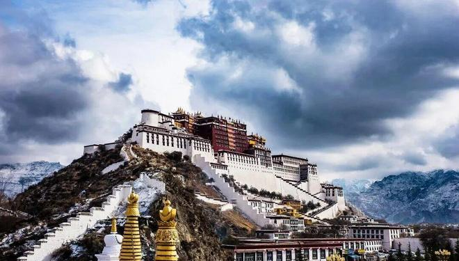
Tibet
The bunker
The bunkers are mostly stoned, the walls are very strong and the outer walls are gradually shrinking. Flattops. Small windows
Xinjiang
Xinjiang is hot and dry, and wood is scarce, but of good soil quality, so the traditional uighur people live mainly in earthy buildings, mostly single or double arches with basements
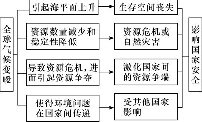
Impact of climate warming on the geographical environment

(1) climate
Global warming can lead to extremely high temperatures in parts of the world, while at the same time it can trigger extreme temperatures, which can lead to increased frequency of weather hazards。
Rainfall changes caused by global warming are more volatile than temperature changes, with frequent extreme weather events, such as droughts and heavy rains, and increased weather hazards。
(2) landscape
Global warming leads to sea-level rise and increased wave erosion, thereby altering the landscape of coastal areas。
Increased wave erosion has led to increased water power conditions in coastal areas and slow or even reduced growth in the estuary delta。
(3) hydrology
1 oceans: global warming affects circulation, which can be influenced by prevailing winds; the melting of high-latitude glaciers leads to significant changes in sea temperature, sea salinity, sea water density in different areas, and influences ocean current movements in terms of seawater nature。
2. Coasts: increased storm surges and a retroactive increase in salt surges resulting in economic losses to coastal areas; higher sea levels and increased coastal erosion could lead to seawater intrusion, resulting in increased groundwater salinity and soil salinization in coastal areas。
3 land: rivers with high-altitude ice and snow melt as the main source of recharge, which may increase run-off in the short term due to the increase in high-altitude ice and snow melting; long-term retreats of glaciers may lead to the eventual reduction or even drying up of river runoff。
(4) biological
Changes in vegetation distributions, such as subtropical forests, which may evolve into tropical forests, temperate grasslands may expand northwards, etc., are more evident, especially in transition regions. Like the change in surface vegetation in the northern part of our yellow-earth plateau。
While accelerating forest growth, it may reduce the quality of wood, leading to maturity, ageing and even decline of existing forests。
3 this leads to increased water evaporation and drying of forest soils, leading to increased frequency of forest fires。
4 biodiversity is reduced and biocide is significant, with the potential to accelerate the generation of new species。
(5) natural disasters and diseases
In sum, meteorological and hydrological disasters caused by global warming may also induce geological disasters that eventually lead to a high incidence of global natural disasters。
(b) the spread of some diseases, especially tropical diseases such as malaria; the incidence of some diseases has increased, especially in the summer when extreme temperatures lead to heart disease and various respiratory diseases。
(6) agriculture
Global warming can increase the range of pest activities subject to temperature restrictions, leading to an increase in agricultural pests and pests, especially at high latitudes。
2 meteorological disasters caused by global warming adversely affect agricultural production。
Changes in calories may, in general, result in reduced crop yields in most countries at low latitudes and increased crop yields in most countries at high latitudes. For example, in new zealand, global warming has led to an increase in the production and quality of local grapes。
4 impacts the development of seawater farming in coastal areas。
(7) transport
Improved shipping conditions on high-latitude routes facilitate the development of transport in coastal areas, such as arctic routes。
Sea level rise may affect port and channel functions in some areas。
(8) national security