I've been doing geography
Currents are an important engine for the transfer of heat on earth. Currents regulate the north-south temperature difference, which is often the case in the coastal zone, where temperature lines are often parallel to coastlines. The nature of the seafloor mats is uneven, and their differences are manifested mainly in cold and warm currents. The current is the focus of the year-long exams, and i want more practice and memory
Current classification
Press cause
Currents are divided into wind currents, density currents and compensatory streams。
Wind current: generating atmospheric motion is large. For example, the western wind drifts, and the currents in the wind belt。
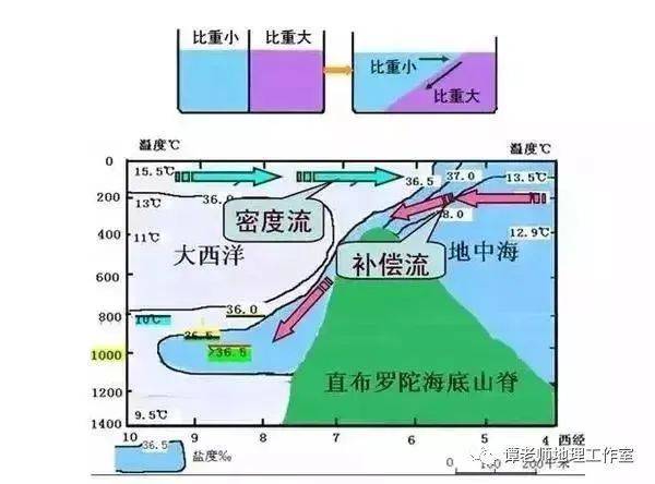
Density streams: these are caused by density differences, mostly between the closed sea and the outer ocean. For example, between the mediterranean and atlantic, between the red sea and the indian ocean。
Reimbursable streams: horizontal and vertical, mostly on both sides of the ocean. For example, the equatorial reverse, the cold in peru。
By nature
Currents are classified by nature as warm currents and cold currents。
Warm currents: from hot sea areas to low-water areas, mostly from low latitudes to high latitudes or downstreams. Typically, there are warm currents in japan and in the gulf of mexico。
Cold flows: from low-water to high-water areas, mostly high-latitude to low-latitude or upstream. Typical are thousands of islands and labrador。
By geographical location
Currents are divided by geographical location into four types of equatorial, oceanic, polar and coastal streams。
Equator currents: distributed around the equator. For example, north-south equatorial warming, equatorial reverses。
Ocean currents: they are distributed in the centre of the ocean, and they are more of a type。
Polar currents: in polar waters. For example, antarctica bypasses extreme flows。
Coastal currents: distributed over coastal waters and highly affected by land. For example, our coastal current。
Factors affecting current distribution
The flow and distribution of ocean currents is closely related to the pattern of the surface wind belts and their distribution。
In addition to prevailing winds, there are factors such as land and sea distribution and geo-diversion, which together shape the actual ocean current distribution, as illustrated below。
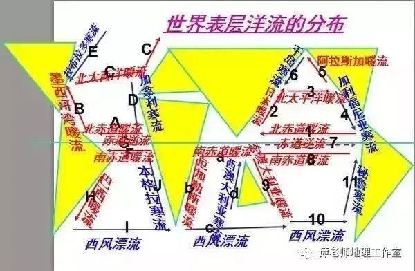
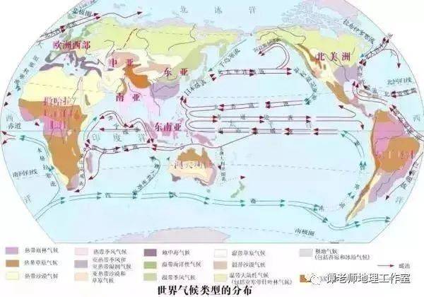
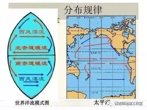
Current distribution patterns
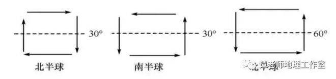
1. In the tropics and subtropical seas (middle and low latitudes), ocean circulations centred on the subtropical seas (30°) are formed, with the northern hemisphere moving in a timewise direction and the southern hemisphere in a reverse timewise direction。
2. In mid-latitude and high-altitude areas, a 60-° ocean circulation has been formed, with the northern hemisphere moving in a reverse acoustic direction。
3. Around the antarctic continent, the land is small and the sea is vast. The sea area near latitude 40° s was affected by the western wind throughout the year, which formed the west wind drifting (cold current)。
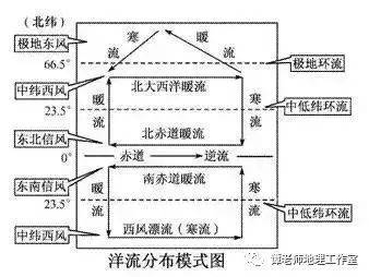
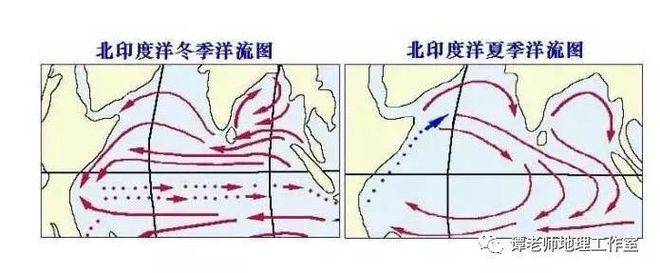
4. In the north indian ocean sea region, affected by monsoons, the winter current flows in reverse-hourwise direction, while the summer current flows in a smooth-hourwise direction。
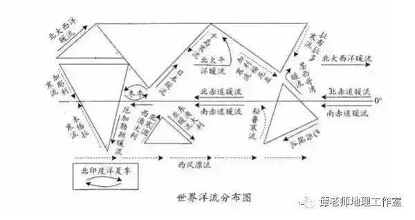
Important currents
Pacific: warm currents in the north pacific, warm currents in japan (black tide), cold currents in thousands of islands (brother tide), cold currents in california, cold currents in peru, warm currents in east australia
Atlantic ocean: north atlantic, gulf, labrador, benguela, canary, brazil。
Indian ocean: cold currents from western australia, northern indian ocean monsoon currents。
Globe: the west wind drifts。
Impact of ocean currents on geographical environment
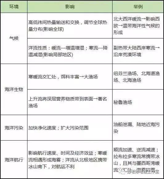
Current applications
The method of judging current flows
1. Current cause method: based on the intrinsic link between current distribution and air pressure bands, wind bands. The western wind belt affects currents generally from west to east; the wind belt affects currents generally from east to west。
2. Current properties: the water temperature is lower than that of the current sea area, and the water temperature is higher than that of the current sea area, and the general cold flow flows from higher to lower latitudes and from lower to higher latitudes。
3. Temperature lines such as seawater bending: the direction in which the thermolines rise is the flow of currents。
4. Geographic approach: east-west currents of the lower mid-latitude ocean flow to the lower latitudes, west bank currents flow to the higher latitudes; high-latitude east-west currents of the northern hemisphere flow to the higher latitudes and west bank currents flow to the lower latitudes。
How to judge the warmth of currents
1. Based on the bending of the temperature line such as seawater: the temperature line cleaves to higher latitudes, and to lower latitudes to cold。
2. Judging from the environmental characteristics of the ocean currents: desert landscapes along the coasts of mid- and low-latitudes indicating exposure to cold currents; wet-hot forest landscapes indicating exposure to heat currents。
3. Judging from weather phenomena: sea areas with perennial mist weather phenomena are generally affected by cold currents。
4. Based on the location of the sea and land: in the medium and low latitudes of the sea, the eastern bank of the ocean (the mainland west bank) is cold, and the western bank of the ocean (the eastern coast of the mainland) is warm. In the mid-latitudes of the northern hemisphere, the eastern bank of the ocean (the mainland west bank) is warm and the western bank of the ocean (the eastern coast of the mainland) is cold。
How to determine the south, the north
Determination based on latitude and circulation direction: first step: determination of the sea area (subtropical or subpolar sea area) based on latitude (30° or 60°); second step: application of surface current distribution maps based on current direction (inward, reverse); third step: application of surface current distribution。
Applied techniques in current judgment
1. Determination of the northern and southern hemispheres based on the direction of circulation of currents at mid- and low-latitudes. Ocean circulation flows in the direction of clockwise in the northern hemisphere; ocean circulation flows in the direction of counterclockwise in the southern hemisphere。
2. The north and the south are determined by the nature of the western wind drift: the western wind in the north is warm and the western wind in the south is cold。
3. The defined season is based on current flows from the north indian ocean: the currents flow in time to the northern hemisphere in summer and vice versa in winter。
4. Ocean currents are insulated from thermolines: they are dense at the concourse of currents; they are back to the flow, and they are thin。
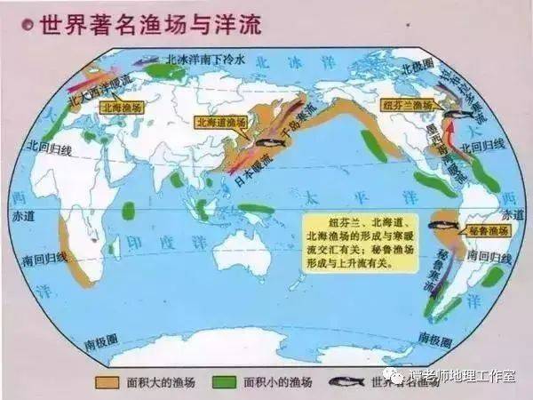
5. Ocean currents and fisheries: sea areas with fishing grounds may be hot spots or upscaling。
A few irregular currents
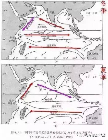
The north indian ocean ocean current season changes, but it's warm
Among world currents, the north indian ocean sea region is dominated by monsoon circulations, which show marked seasonal variations in the course of the year。
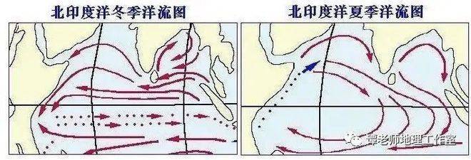
In the summer, the south-west monsoon affected the flow of sea water eastward, and in the winter, the north-east monsoon affected the flow of seawater westward. Because of this peculiarity, it has often become a focus of the examination, as well as a focus and difficulty in learning。
North indian ocean monsoon circulation
North indian ocean currents: the north indian ocean, affected by the tropical monsoons of south asia, has experienced large-scale surface sea-water flows, resulting in ocean currents, the cause of which is known as the northern indian ocean monsoon circulation. The north indian ocean currents, however, have marked seasonal variations, and the circulation systems across the indian ocean have not only varied in the winter and summer seasons, but also in the currents that make up the circulation system。
Then i will specify the direction of north indian ocean currents in different seasons:
Winter moves in reverse timewise direction
In winter, the asian continent was under high air pressure, while the indian ocean was under pressure, blowing the north-east monsoon from the asian continent to the indian ocean, so that the waters of the northern indian ocean flowed westwards by the north-east monsoon, and the currents flowed counter-clockwise. At the same time, the circulation system throughout the north indian ocean region consists of monsoon currents, somali warm currents and equatorial reverses。
Summer flows in a clockwise direction
In the summer, as the direct point of the sun moves northwards, the air-pressure and wind belts then move southward, causing the south-east of the southern hemisphere to cross the equator to shift to the south-west monsoon, when the sea is eastward and the current flows in the direction of the clockwise ... At the same time, the circulation system throughout the north indian ocean region consists of monsoon currents, somali colds and southern equatorial warms。
The monsoon currents in the northern indian ocean are generally warm, both in winter and summer, because the sea is located within the tropics and the water is warmer than the equatorial currents at low latitudes. Mr. Tan's geographic studio has been consolidated
Somali currents also change seasonally, but it's cold. Warm
Strictly speaking, the somali current is part of the current in the north indian ocean。
In winter, the north-east monsoon affected somali currents from high to low latitudes, but the winter somali currents are warm because of their tropical location and high surface temperatures。
In the summer, the south-west monsoon was prevalent, creating off-shore winds in the somali peninsula, which led to cold seawater at the bottom, which, although moving from low to high latitudes, is cold。
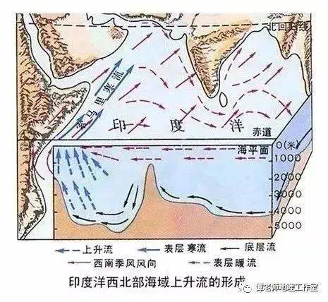
Somali current
The somali current is indeed an exception. Its specialty is that it's cold in the summer and warm in the winter. It is seasonal and the only ocean current. In winter, it was also the only warm current in the world from high to low latitudes。
As can be seen from the bottom left of the world current map, in the summer there is a cold flow from lower latitudes to higher latitudes in somalia in the northern indian ocean, which is different from the general pattern of distribution。
The causes of the summer cold
(1) analysis based on a comparison of currents with water temperature passing through the sea zone. The region around the arabian sea is dominated by tropical desert climates with particularly dry air and a rapid rise in summer temperatures; at the same time, the arab sea is covered by hot air, with higher surface temperatures. The waters that flowed from the coast of east africa, although from the surface near the equator (low latitudes), are still below the water temperature of the arabian sea, thus creating a summer cold current for somalia
(2) analysis based on the type of cause of the current. In the summer, under the south-west monsoon, the surface waters of the arabian sea left the shore, while the waters of the nearby east african coast compensated for the run-off and formed an upward compensation stream. The flow of somali currents from low to high latitudes during the summer is known to be of a cold-flowing nature according to the pattern of vertical erosion of surface seawater。
In general, the currents affecting somalia are cold in the summer mainly because of the departure of the somali coastline from the summer wind, which is characterized by offshore winds, cold water in the lower layers of the sea, which is just northwards, and cold flows from low latitudes to high latitudes, with the effect on the coastal climate of cooling and damping, exacerbating the drought in the summer of somalia。
The causes of winter heat flow
(1) low latitudes, dry coastal climates, low clouds, high solar radiation, higher temperatures throughout the year and more solar radiation, which is the main cause of high sea temperature;
(2) the dry tropical desert climate along the coast, without the influx of rivers and less diluted sea water - hence high salinity;
(3) although the sea area is open to the south, its location near the equator, combined with the formation of circulation flows, makes it possible to preserve the high temperature and salt of the sea near the equator by allowing less sea water to be fully shared with that of the southern ocean。
The analysis of winter warm currents must correspond to the summer cold, which intersects with the somali coastline, making the coast ashore wind that accumulates, and then sinks, forming near-shore and sub-shore and sub-surface and sub-surface hot and sub-winding, forming a warm stream. Owing to the dry-hot character of the downflow, the winter in somalia has not been wetted by warm currents。
In general, it is cold flows from high latitudes to low latitudes, it is warm flows from low latitudes to high latitudes, while the somali currents do not follow normal logic。
The western winds in the northern hemisphere are warm, the southern hemisphere is cold
The west wind is driven by a strong west wind, and the sea is flowing eastward。
In the northern hemisphere, the western wind drift is a continuation of the warm currents of japan and the gulf of mexico, respectively known as the north pacific warm flow and the north atlantic warm flow. As these two warm currents of sea water flow from low latitudes in the western ocean, they are warm currents。
What is the cold-flowing nature of the west wind, which flows from the west to the east on the vast ocean near 40°-60° s under the prevailing west wind? The impact of the antarctic continent has been decisive。
1. The west wind drifting in the southern hemisphere flows around the antarctic continent, where the climate is cold throughout the year and the ground is always covered with heavy ice and snow; the southern ocean is at lower temperatures than the northern hemisphere at the same level as the arctic。
2. The ice-tongue that extends from the antarctic continent leads to drifting icebergs that melt with large amounts of thermal energy, thus reducing sea temperature. According to statistics, there are approximately 218,300 icebergs weighing over 100,000 tons, with an overall population of 179 million cubic kilometres; these ice sheets absorb sea water heat in the southern ocean, further reducing sea temperature。
3. The strong and dry easterly winds of the antarctic continent cause high latitudes to flow northward, exacerbating the cooling of seawater。
4. West wind drift is spread over the sea at latitudes of 40°-60° s, with high latitudes, small angles of the solar altitude and low total annual solar radiation. Second, the total amount of solar radiation reaching the ground has been further reduced by the fact that the western winds drift in the temperate zone of the southern hemisphere, with heavy-fronter rain, cyclone rain and heavy rain weather, and only 80 to 120 kilocalories per square centimetre per year。
In the summer (january), the earth is located near the near-day point of the public orbit, with a relatively rapid rotational angle, with a shorter summer time and a temperature of not more than 10°c even in the summer. As a result, winds drifting in the western hemisphere are of a chilly nature。
China's ocean flow
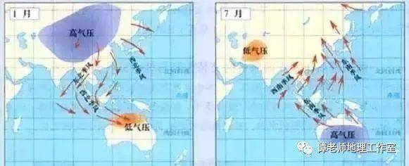
Seasonal changes in coastal flow systems are influenced by changes in continental runoff. It is also affected by monsoon changes. Consistent with monsoon changes. From november to february of the following year. Under a strong north to winter monsoon. The coastal system from north to south is strongest. The largest expansion was in the march-may monsoon transition months. The coastal currents in the south are weak and strong throughout the coast. In june, july and august were the summer seasons of the monsoon. The coastal current north of hangzhou bay. Even from north to south. But it's getting weaker. And south of hangzhou bay. East sea. The coastal currents of the south china sea converge with the warm current system of the outer sea. Moving from south to north, september and october are also seasonal transition periods. The summer monsoon was gradually replaced by the winter monsoon. The coastal flow from north to south is gradually increasing. And spread south。
My country, hoang sea. The currents of the east sea consist mainly of two streams, the black-tide warm current and the coastal current. It has the characteristics of a cyclone circulation. Among them, the black-tide system is dominated by the black-tide system and its branches (taiwan warm current). It's made up of horse and yellow currents. The coastal flow system runs from north to south, mainly from liaonam. Liaodong river. A sea current. Su-north coast currents and mussels. The south china sea is located in the tropical monsoon zone. In summer, the southwest wind prevailed. In winter, the north-east wind prevailed. The direction of monsoons is consistent with the axis of the sea chief. So it helps to stabilize the development of currents. The surface circulation of the south china sea is played by the wind. Have monsoon drift characteristics. During the southwest monsoon. The south china sea is northeast. Northeast monsoon. Most of the area is southwest。
The factors affecting seasonal changes in current systems in china's offshore and adjacent maritime areas are complex. General. Seasonal changes in the main sectors of the black-tide system are as follows: the black-tide seasons are irregular. Some years of winter and summer are weak. In some cases, the year is the same as the summer, autumn and spring, or summer and summer, and the speed and flow of the horse warm is characterized by the annual cycle. The flow speed is highest in september. In february, the smallest, the speed of yellow-sea warm currents also varied significantly from season to season. Usually winter is strong. In the summer, when the heat flow of taiwan is weak, the speed of the warm flow is clearly seasonal. Summer strong. The winter is weak and the surface flow of the south china sea is as described above. Summer for the northeast. Winter is southwest. Winter and summer. The western part of the south china sea is stronger than the eastern part. It's off the coast of vietnam
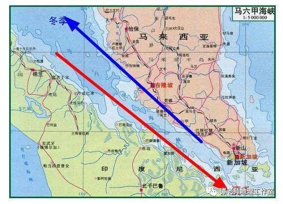
The malacca strait current
The strait of malacca, located between the indian ocean and our southern sea, is subject to the combined effects of monsoon and ocean currents in the northern indian ocean and those along our southern sea. The monsoon current in the north indian ocean is familiar: winter currents in november-march and summer currents in may-october are counterclockwise. The northern equatorial flow runs west from the vicinity of sumatra and the malay peninsula to the southern edge of sri lanka and to the southern arabian sea, and the malacca straits, but mainly the equatorial reverse. Winter currents in the south china sea go south near viet nam and the malay peninsula, most of which flow through the karimata and kaspa straits into the java sea and a small part of the sea water into the malacca strait. In the summer, contrary to winter, the currents reach the vicinity of sumatra, most of which cross the equator southwards into the southern equator, while a small portion enter the strait of malacca, while the coastal flow of the south china sea follows the south-west wind north-east, causing the currents of the strait to flow from the indian ocean to the pacific ocean. It should be noted that the strait of malacca is in an equatorial zone free of wind, with long periods of calm, and that ocean currents that occur should not be classified as wind currents, but rather as compensatory streams。
Classic case resolution
The figure below shows the distribution of currents in selected areas. Question (1)-(2)。
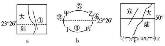
(1) the following description of currents in the figure is correct:
A. If a current flows from north to south, a current is cold in the northern hemisphere
B. If two currents flow from south to north, two currents may warm japan
C. If three currents flow from west to east, three currents may warm the north atlantic
D. If six currents flow from the south to the north, six currents may warm the southern hemisphere
(2) if the ocean circulation in figure b is current-hourwise, the reasons for the formation of areas and fisheries in areas a, b, c, d are correct:
A. At a. The cold flow of the sea into the fishing grounds
B. B. There is a cold stream (upgrading compensation stream) that forms the fishing grounds
C. C. On the shallow continental shelf, in good light
D. D., seawater warmth, which helps to form a fishing grounds
The answer is:
(1) if two ocean currents flow from the south to the north, the circulation is a mid-latitude circulation in the north and possibly a warm current in japan; if one ocean current flows from the north to the south, one ocean current is a warm current on the eastern shore of the southern hemisphere; if three ocean currents flow from the west to the east, it is a low-latitude circulation in the southern hemisphere and three ocean currents may drift from the west; and if six ocean currents flow from the south to the north, six ocean currents may be a warm flow on the west bank of the high continental latitudes in the northern hemisphere。
(2) if the ocean circulation in figure b is transient at a time, the circulation is a mid-latitude ocean circulation in the northern hemisphere, and the area prone to fishing is a, where there is a warm and cold flow。
Reference answer:
(1) b (2)a
I'll search for the hot articles you're interested in