Source: chinese academy of sciences
Ground-based radar is one of the means of effective remote sensing of the moon and even other bodies of the solar system. It provides much information on the physical properties of the lunar weather layer, such as the abundance of rock on the surface and subsurface of the moon, the thickness of the weather layer, the iron and titanium content, the distribution of impact meltings, and the top mass topographic maps. The current ground-based radar moon imagery is mainly carried out through two radars, arecibo and haystack, in the united states, which have been relatively small owing to the lack of appropriate equipment and related experimental designs and data-processing experience. There have been some recent preliminary studies in the field of ground-based radar lunar detection, such as the two-basket expeditions based on the kash deep space station and the kunming 40-metre radio telescope, and the spontaneous self-absorption of barccom pulse signals based on the concordian dispersive radar, but many issues remain to be resolved, both in experimental design and algorithm research。
In response to these questions, the research team of the geological and geophysical research institute of the chinese academy of sciences, using the recently completed trans-asian-african consorteous scatter radar, conducted a preliminary experiment on moon imaging and carried out an experimental design and data-processing algorithm study. The team used two launch waveforms — 13 buck codes and linear fm pulses — to conduct moon imaging experiments and developed three key technologies: one, nucleus imaging, using the distance doppler imaging algorithm commonly used in synthetic aperture imaging; two, an impervious filter to avoid 13 buck codes matching the edges of the filter; and three, to address the “north-south fuzzy” problem, using the moon's front doppler north-south hemispheric integration technique。
The study produced two types of imaging: images of the global hemispheric integration of the moon and local area images (figure 1). The imaging results have a distance resolution of 500 m and a location resolution of 1. 2 km. The results have demonstrated the feasibility and reliability of moon imaging based on sanya radar and have accumulated experience in ground-based radar moon imaging experimental design and data processing, which has made it possible to conduct future moon geology studies using our ground-based radar。
The study also found that while the distance from the doppler algorithm used in the tradition was efficient to calculate it, it resulted in image blurring when the relevant accumulation time was too long to obtain higher resolution. In response, the research team proposed the application of backward projection algorithms in reverse synthetic aperture imaging techniques to focus the image of the moon. The backward projection algorithm is a time-area algorithm that theoretically allows for a focused imaging of each pixel point over any extended period of time associated with accumulation, but the defect of the algorithm is the high complexity of the algorithm, so the study used the algorithm to experiment with imaging of parts of the moon. Using linear fm pulses, the team launched right circular polarized electromagnetic waves, received left circular polarized echoes, and, using distance doppler algorithms and backward projection algorithms, the pythagoras impact crater area was imaged and compared (figure 2). The results show that the backward projection algorithm can be well applied in the ground-based radar moon imaging experiment and has some focus properties, but the degree to which this focus improves the image quality needs to be further quantified; furthermore, the backward projection algorithm is inefficient and requires the development of rapid algorithms to improve computing efficiency。
The results of the study are published in ieee transports on gender and remote sensing and remote sensing. The research work is co-financed by the centre for strategic science and technology (category b), the midday project and the national natural science fund project。
Articles link: 1, 2
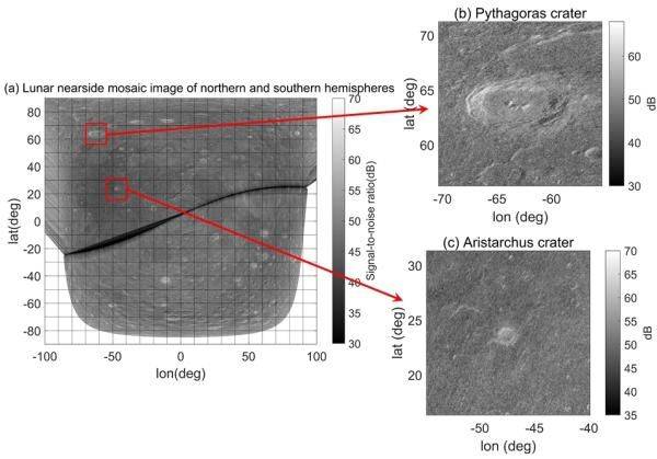
Figure 1 (a) fusion image of the northern and southern hemispheres on the face of the moon; (b) map of the area of the pythagoras impact crater; and (c) map of the area of the aristuck impact crater figure
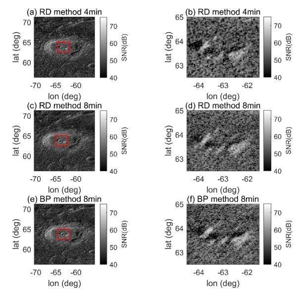
Figure 2 the left column is a map of the area of the pythagoras impact crater and the right column is a magnification of the area of the red rectangular frame of the left column. (a), (b) 4 minutes from doppler algorithm, cumulative; (c), (d) 8 minutes from doppler algorithm, cumulative; (e), (f) 8 minutes from backward projection, cumulative