The book has built a geological disaster database of the kawaji transport corridor around the complex geological background and geological disaster prevention and mitigation needs of the eastern tectonics of the tibetan plateau, using a combination of multiple sources of remote sensing, geological surveys, geological age years, experimental tests, physical simulations and numerical simulations, and has explored in depth the pattern of retrogression of mega-high remote slopes, which has effectively served to protect the region from major engineering and major urban geological disaster risks。
The tibetan plateau is the highest-lying, most young and most tectonic plateau in our country and in the world, the most advanced of the geological age, known as “the ridges of the world”, with steep terrain, large land rises and rises in the region, a region that is highly developed and active and prone to earthquakes, which have long attracted the attention of countless scholars. In particular, the unique geological background and complex fracture zone systems of the eastern tectonic zone of the tibetan high plateau have made geological disasters in the region, especially those closely related to tectonic activity, such as large ancient landslides, long-range landslides and seismic landslides, very complex spatial and temporal distributions and evolutionary features, becoming key zones for global geological, disaster geology and engineering geology studies. With the intensification of global climate change and the deepening of human engineering activities, the mechanisms of geological disasters and the pattern of post-disaster evolution in the region have become more complex and the issue of disaster prevention and mitigation has become more acute and requires in-depth analysis and systematic research。
In recent years, with the support of projects such as the china geological survey's “technology and geological survey of transport corridors in the tsangxi-tzudong region”, the team of guo changbao fellows of the geological mechanical research institute of the chinese academy of geology, based on the need for major engineering planning for disaster prevention and mitigation in the eastern part of the tsingshi plateau, has carried out a number of studies and comprehensive studies on the characteristics of the development of the geological disaster in the critical activity tectonics, the mechanics of the disaster and the evaluation of the risk, and has produced a book entitled “study study on the mechanisms of geological disasters in the eastern part of the tsingshi plateau of activity”, which provides an important theoretical basis and data underpinning the understanding and prevention of the geological disaster in the tsingshi plateau。
The book provides a comprehensive analysis of the patterns of geological disaster development in the main tectonic zones in the eastern part of the tibetan plateau, constructs a geological disaster database of the kawajia transport corridor, presents a model for geological disaster vulnerability and risk assessment that takes into account tectonic activity, and systematically assesses the susceptibility and risk of geological disasters in large-scale activity fracture zones, such as the long gate mountain fracture zone, the fresh water river fracture zone, the bar tong fracture zone, the furious river fracture zone, and the jali-chat fracture zone. The book provides an in-depth study of typical landslides, such as the sichuan baang-dedda landslide, the tibetan river davoda landslide, the baig landslide and the yigon landslide. It illustrates patterns of re-emergence of remote erosion of mega-high slopes. It proposes mechanisms to promote and accelerate the recovery of the great landslide-golden-delve disaster chain from the lower slopes. It analyses the mechanisms for the recovery of the great landslide recovery mechanism and major sudden geological disasters in the inner zone, which are structured in cooperation with internal and external power forces. The findings of the book greatly enrich the theoretical framework for geological disasters in the tibetan highlands and promote the interdisciplinary integration of research on mechanisms for the causes of disasters, which can effectively improve the ability to identify the hazards of geological disasters and enhance the foresight and precision of geological disaster prevention。
The geological disasters in the eastern tectonic zone of the tsang tibetan plateau are extremely complex and involve a complex mix of tectonic, climatic and seismic factors. It is on the basis of this multi-dimensional perspective that the book not only further promotes the level of research in this field, but also draws on the more future studies on the mechanics of large-scale geological disasters in the tibetan highlands. It is hoped that the results of the study will serve as a reference for scientific, managerial and engineering technicians working in related fields, promote geological safety and sustainable development in the tibetan highlands and make new contributions to geohazard research and prevention. In conclusion, express our sincere congratulations on the successful publication of the book
Member of the chinese engineering college
3 december 2024
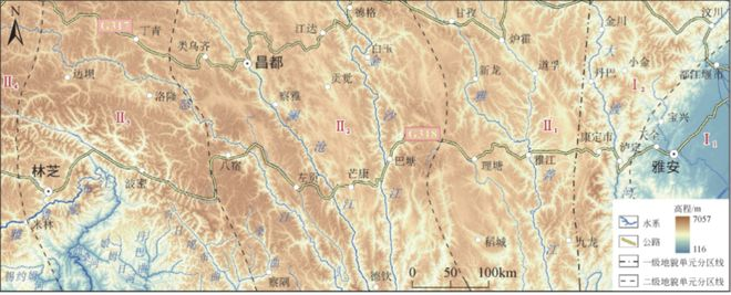
Topographic map of the kawajia corridor
Main research content
(1) qualifications of the development of geo-hazards along the kawatsu transport corridor: analysis of the characteristics and patterns of the development of the geo-hazards in the region, assessment of the disaster vulnerability of the kawatsu transport corridor, and assessment of the risk of the earthquake slide in the region。
(2) assessment of the stability of the ancient landslide in the fratricidal zone: on the basis of an analysis of the spatial displays and activity of the ripples of the river, a study was carried out on the developmental characteristics of the geological disaster in the fracture zone of the river, focusing on the analysis of the stability of the typical large-scale landslides, such as the ancient slopes on the high lawn and the ancient slopes on the gavage village。
(3) risk evaluation of seismic landslide in fresh water fracture zones: on the basis of an analysis of the characteristics and activity of the spatial display of the fresh water fracture zone, the main factors influencing the development of the geological disaster in the fresh water fracture zone were analysed, and the risk assessment of geohazard susceptibility and seismic landslides was carried out. At the same time, an analytical study focused on the developmental characteristics and risks of geological disasters induced by the 2022 sichuan tsichuan tsichuan (photo-tectonic) ms6. 8 earthquake。
(4) developmental characterization and risk evaluation of the geological disaster in the papond fracture zone: on the basis of an analysis of the spatial displays and activity of the bachang fracture zone, a further analysis of the spatial and temporal patterns and developmental characteristics of the bachon battery zone disaster, an analysis of the conditions and impact factors for the formation of the geological disaster, an assessment of the proneness of the landslides and the risk of seismic landslides, and a focused analysis and study of the resurgent deformations and impact factors of the delta and zama slopes。
(5) large slope development characterization and early identification study of the upper part of the jinsha river, based on an analysis of the geologic development patterns of the upper part of the river from jinsha river to bagang, an early identification of the risk of large landslides based on remote sensing techniques and an analysis of the mechanisms for deformation and destruction in the context of typical large landslides cases validated the effectiveness of remote sensing techniques in early identification of large landslides。
(6) a study of the disaster chain of the kali-chachi fracture zone at a remote slide: on the basis of an analysis of the characteristics and activity of the plaque of the carly-chamber fracture zone, the typical high-level long-range chain disaster along the fracture zone and the conditions for pregnancy were further refined, and a risk assessment of the high-land long-range slide disaster chain was carried out, targeting the tibetan igon high-land long-range landslides and the tibetan long-range long-range landslides in the bomi tea longbash in tibet。
Click on a picture to jump to buy
The book is a monograph for research and technical staff in the fields of geological disasters, seismic geology, engineering geology, geotechnical engineering, geological safety and major engineering planning, as well as for teachers and graduate students in higher education。
Slide left and right. View directory
The paper is taken from the scientific publisher's book " research on the mechanisms of geological disaster in the tectonic formations of the eastern tibetan plateau " , published in december 2024, with deletions. Add the title to the title。