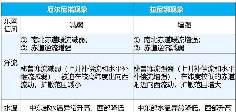
The el niño and la niña school of studies: and the county's first high school year: two seniors: two seniors: one senior class. The group's activities explored the concept of the walker circulation 1. Figure 3. Circulation pattern 3. Thermal circulation is formed over the pacific ocean near the equator. The strong and weak change of the walker circulation is an important basis for judging the occurrence of the phenomena of 6 and 7 . Ii. Activities of the panel explored the phenomenon of el niño 1. The el niño phenomenon of low-latitude equatorial reverses due to the el niño phenomenon, which are weaker than normal years,9 () north-south equatorial warming,8 () walker circulation,11 () the loss of warm water to 10 () in the pacific equatorial zone. The circulation pattern map requests the production of an el niño circulation model chart 4. Impact 1) in the eastern part of the pacific, near the equator, the sub-sinking currents of the walker circulation14 , or the disappearance of, or even the occurrence of 15 , the climate from the original 16 to the heavy rain, causing a disaster of 17 . 2) in the western pacific ocean near the equator, rising air currents in the walker circulation range of 18 or 19, with climate change from 20 to 21 causing a disaster. 3) weakened by 23 on the eastern side of the ocean near the equator, 24 weakened by the flow and nutrients of the ocean surface 25 , fishery 26 . 4) the effect on the country is 1° to reduce the winter wind, the weather and the phenomenon (cold winter/cold winter). Think: why? Proceeding from differences in the nature of the heat from land and sea (at a time when temperatures in the western pacific are reduced to form a cold water zone), 2° in the summer wind in our country is slow to move and may occur. Think: why? Proceeding from the formation of the air-pressure belt, (tip: lower temperatures in the western pacific form a cold water zone that weakens the flow movement of the equatorial low-pressure belt) 3° of our summer typhoons think: why? From the onset of typhoon, the activity of the group explored three: la niña at 1. 01: the north-south equatorial warmth flow 27() equatorial reversible 28() pacific equator warm water flow to 29() walker circulation 30() la niña in the vicinity of the equatorial region. Circulation pattern maps are provided for la niña circulation mode figure 4. Impact 1) eastern pacific near the equator: 33 above normal year temperature, 34 above precipitation. 2) western pacific near equator: temperature 36 , precipitation 37 and even 38 . Note: temperature differences increased in the eastern and western parts of the pacific region near the equator following the la niña phenomenon. 3) increased offshore winds on the eastern side of the pacific ocean near the equator to increase compensation streams of 39 , surface nutrients of 40 and fisheries 41 . 4) the effect on the country is 1° that increases the winter winds, increases the weather and occurs (cold winter/cold winter). Think: why? Proceeding from differences in the nature of the heat from land and sea (tip: at this point in time of lower temperatures in the western pacific ocean to form a heating tank) 2° in the summer wind in our country is accelerating, and the phenomenon is likely to occur. Think: why? Proceeding from the formation of the air-pressure wind belt (tips: lower temperatures in the western pacific ocean at this point in time to form a heating tank, which makes the equatorial low-pressure zone dynamic) 3° of the country's summer typhoons think: why? Proceeding from the formation of typhoons, the scientific network (beijing) inc. (at a time when lower temperatures in the western pacific form a heating tank, which strengthens the transient movement in the equatorial pacific west bank)