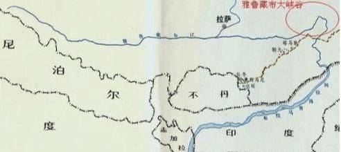
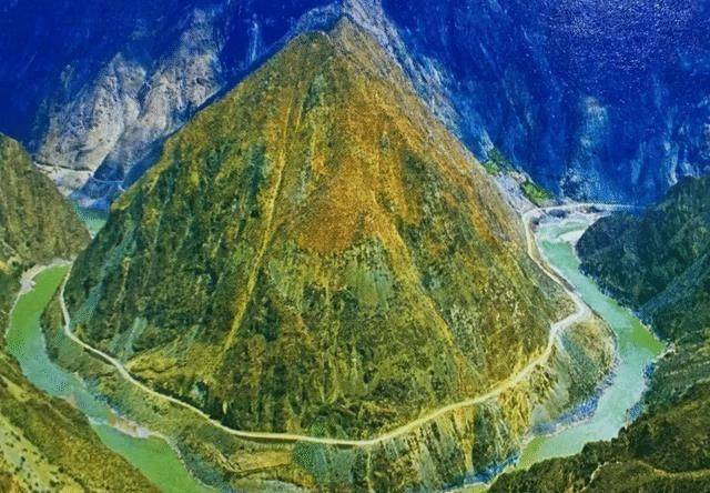
The yaruzzib river is the first river in the country's highlands, 2900 kilometres in length and a basin of 617,000 square kilometres into the gulf of bengal in the indian ocean, an international river. There are three countries, namely, china, india and bangladesh. It originated in the jemayang glacier of the himalayan mountains of our country's tibetan highlands, which originates from the maquan river, an area of 2104 km across the country, with a watershed area of 240,000 km2, with a total gap of 5435 metres. - the jarucheb grand canyon is the deepest and longest in the world. It then flows to india, known as the brahmaputra river, and then to bangladesh, known as the jamuna river, which then converges with the ganges, and is eventually injected into the indian ocean bay of bengal, with the simultaneous impact on the world's largest delta, the ganges delta。
Our water resources are in the form of “narrow north, south-west, north-west and north-west”, which is why a century-long project known as “northern to north” has led to the diversion of the yangtze river to north china to alleviate the drought in north china. Since the river is so rich in water, and the annual runoff is second only to the yangtzeb rivers and pearl rivers, can we bring the river's rich water resources to robo in xinjiang? And why
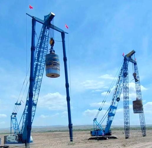
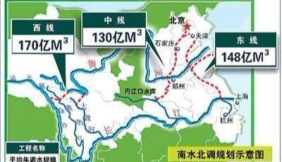
The answer is yes, yes, but it is quite difficult, with long construction cycles and higher costs. First of all, i would like to introduce our country's “northern water” project. The aim is to address the water shortage in the north and north-west of the country and to alleviate the drought conditions there. The work was divided into three sections: the east, the middle and the west. The east line project, with an annual water transfer of 14. 8 billion cubic metres and 1,156 kilometres in length, has now begun a successful water transfer to the north china region through the original kyoto hang canal waterway: the midline project, with an annual water transfer of 13 billion cubic metres and a length of 1432 kilometres, has also begun a successful water transfer to the north china region from the dan river mouth reservoir in hanjiang, through the taishan mountains. The west line project, with an estimated annual water transfer of 17 billion cubic metres, has not yet been constructed. The programme is expected to be: water from the yangtze upstream to the yellow river, i. E., the construction of water reservoirs in the yangtze river, yagi river and the grand divine river by human labour, the construction of reservoirs in the yangtze river, the construction of dams in the yangtze river, the construction of dams in the yangtze river, the construction of dams in the yangtze river, the construction of dams in the yangtze river, and the construction of dams at altitudes of 2900-4000 metres, the introduction of water-drive holes across the yangtze and the yellow river, and the transfer of water to the yellow river, along the lines of “downward migration, outflow, break, centralization and gradualization”, which are in fact complex and divided into three routes, and we are not over-present。
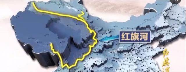
It is believed that many people have heard of the red flag channel project, yes, the red flag channel project, which is in fact the left and right extension of the north-south western line project and the magnification of the western line project. In the western part of china, a dam was built along the edges of the yangtze plateau, with artificial dam-building to connect the yaruzeb river, the anger river and the lantang river to the western part of the country, and later to the western line of the “northern water” project. The water of the yaruzeb river reached the yellow river. It then formed 1,500 kilometres of canals along the western corridor of the river, and then entered the xinjiang region hundreds of kilometres wide, leading to water scarcity in the north-west. Linking the water resources of the shanjde, germu, nain guelleh, timurik and milan river basins into a web of water, completely transforming the seasonal river, the tarrimu river, into a real river, not under seasonal control and not “continue” by melting ice. The rivers of tarimu, which have a steady flow of water, and the tributaries, which are also “spoiled”, are re-emerging, with long-dry sub-talimu rivers, re-emerging springs, re-emerging long-dry lakes such as tatma, robpo, and so forth, re-emerging into new lakes to reach water-scaling purposes, but the process is difficult. The success of the xinjiang waterway in injazeb has led to a long-term virtuous cycle in which the environment and climate in the north-west will change completely, where drought has eased, changing the quality of life that has plagued people for many years and improving their happiness index。
Thanks for reading。