How did the lolong basin, which is a key area for studying the rise of the tibetan plateau and climate response, rise tens of millions of years ago in the middle and eastern transit zones of the tibetan plateau? How has the environment changed
On 3 march, journalists were informed by the institute of the qingxi plateau of the chinese academy of sciences that recent research by the team led by the academy of ting lins on the rise and impact of collisions showed that the lolong basin was only 600 metres above sea level between 54 million and 46 million years ago, rising rapidly to about 2900 metres some 44 million years ago. The rise in the central valley of the tibetan highlands, where the lolong basin is located, is taking place early in the east and late in the west, where the landscape is low。
Using a variety of methods, such as sedimentology, volcanic ashite uranium lead ageology, botanical spectrophoto-thermal altimeter, cosmopolitan altimeter and pollen analysis, the research team quantified the history of the rise and environmental changes of 54 million years ago in the lolong basin, east of the tibetan plateau, to provide strong new evidence for exploring the growth process and environmental impacts of the plateau. This paper on important results of geology research in the tibetan plateau was recently published in the comprehensive academic journal national science review (nsr)。
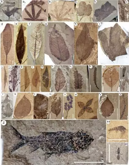
This study is a typical petrochemical map of the lolong basin. China academy of sciences, institute of the qingchu plateau
According to the author of the newsletter, dr. Tin lin, the research team carried out numerous field geological expeditions and systematic excavations in the tibetan plateau area from 2020 to 2024, collecting large amounts of volcanic ash, ancient soil calcium nodules, lake limestone and masonal powder samples, as well as over 2,000 fossilized specimens, including plant leaves, flowers, fruit, fish and insect fossils. Of these, phytoforms were the most abundant, covering a wide range of plant types in the tropics, subtropicals and temperate zones, belonging to more than 20 24 species, indicating that the region was rich in biodiversity at that time。
The first author of the paper, dr. Zhao zhao zhou, the ph. D. Of the institute of the quechu plateau of the chinese academy of sciences, noted that in the present study, according to the ancient altitudinal altimeters of the lake gray rock group, the height of the lolong basin was only 600 metres above sea level between 54 and 46 million years ago, and that the analysis of the pollen pollen showed that the basin contained drought-resistant shrubbery, represented by ephemerals, indicating an arid desert environment; some 44 million years ago, the ancient heights calculated using phyllite leaves - thermal hyde - showed that the lolong basin was rising rapidly to about 2900 metres。
Since then, rising surfaces have led to a significant increase in rainfall and a marked shift in dry and wet seasons, combined with phytochemical communities represented by varnish trees, gills, dry plums, etc., indicating that the climate in the lolong basin has been transformed into a relatively warm and wet subtropical mediterranean forest environment, which has spawned mixed biodiversity-rich leaves。
According to dimlin, the central valley of the tibetan plateau is a low-altitude area that has long existed between the candice mountains and the central partition hills following the collision of the indian plate with the eurasian plate. The discovery of the lolong flora and fauna shows that some 44 million years ago, the central valley followed the bangung lake-anger river suture, extending eastward to the vast tibetan-east region represented by the lolong basin. The lolong basin is a key hub linking the central valley and the tibetan east passage mountains. The historical reconstruction of the study revealed that the eastern central valley rose early and the west rose later, and that 44 million years ago it was characterized by a low east-west landscape。
According to the collision and impact team of the qingshi plateau institute of the chinese academy of sciences, over 65 million years ago, the indian mainland has been affected by continuous subduction northwards, including a reduction of 1,000 kilometres of crust in the central valley in which the lolong basin is located, with approximately 50 degrees of acoustic needle rotation in the eastern part of the plateau, and rock cooping mantles in the eastern plateau. In the most deformed areas, the first torn apart and gradually sank into a floppy circle, combined with a voltage surge and large-scale magma activity leading to a rapid rise in the surface。
In combination with the pattern of change in time and space within magma activity and reconstruction at ancient heights in the central valley of the tibetan plateau, they speculated that its rise was mainly controlled by the sinking of the lhasa rock ring from east to west and by the flow of the flounders。