The team ting lin, a member of the chinese academy of sciences and researcher at the qingchu plateau institute of the chinese academy of sciences, has quantified the history and environmental changes of the lolong basin in eastern qingxi plateau, providing new and powerful evidence for exploring the growth processes and environmental impacts of the plateau. The results of the research have recently been published in the state science review。
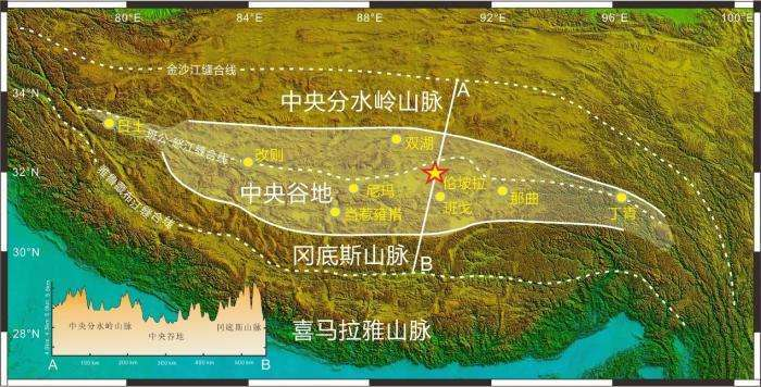
The lolong basin, located in the transit zone between the central and eastern parts of the tibetan plateau, is a key area for studying the elevation of the plateau and climate response. Between 2020 and 2024, the research team conducted numerous field geological expeditions and systematic excavations in the area, and collected a large number of samples of volcanic ash, ancient soil calcium nodules, lake limestone and masonry, as well as over 2,000 fossil samples. Of these, the most abundant is the phyllite, which showed the region to be very rich in biodiversity。
“the ancient isotopic altimeter of lake grey rock indicates that the height of the lolong basin was only 600 metres above sea level between 54 million and 46 million years ago. An analysis of the slurry indicates that the basin contains drought-resistant shrubs, represented by ephedra, instructing arid desert environments.” the first author of the paper, dr. Zhao zhao zhou, was a student of the institute of the qinghua plateau of the chinese academy of sciences, “the ancient heights calculated by the phyll-hot pyrotechnic method some 44 million years ago indicate a rapid rise in the basin to about 2900 metres. High surface rises have led to a significant increase in rainfall and a marked shift in dry and wet seasons, combined with phytochemical communities represented by vasectomy, pyrotechnics, etc., indicating that the climate of the lolong basin has turned into a relatively warm and humid subtropical mediterranean forest environment, which breeds mixed trees of rich biodiversity.”
In response, tinlin stated that the central valley was a low-altitude area that had long existed between the candice and central partition mountains following the collision of the indian plate with the eurasian plate. The discovery of the lolong flora and fauna indicates that some 44 million years ago the central valley was extended eastward to the vast tibetan-east region represented by the lolong basin. The height of reconstruction shows that the eastern central valley rose early and the west rose later, and that 44 million years ago it was characterized by a low east, west and east。
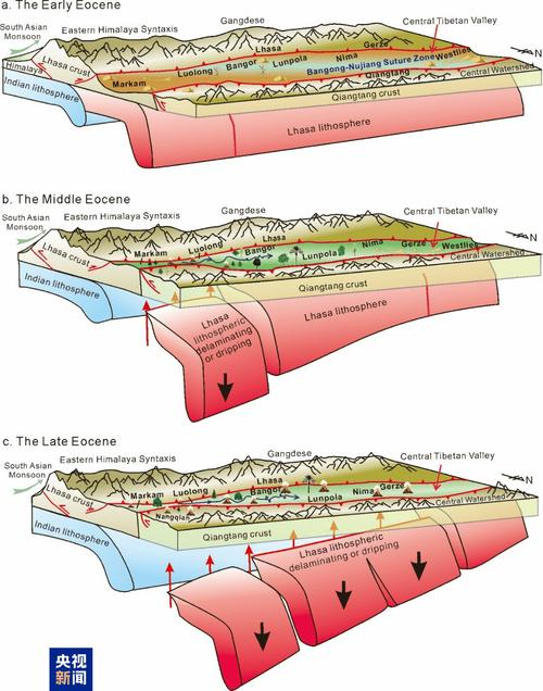
The study concluded that since 65 million years ago, the central valley has absorbed thousands of kilometres of crust as a result of the continued northward subduction of the indian mainland, with approximately 50 degrees of acoustic stroke occurring in the eastern highlands, and rock coils in the eastern highlands. In the most deformed areas, the first torn apart and gradually sank into a floppy circle, combined with a voltage surge and large-scale magma activity leading to a rapid rise in the surface。
Relevant paper information:
Https://doi. Org/10. 1093/nsr/nwaf058