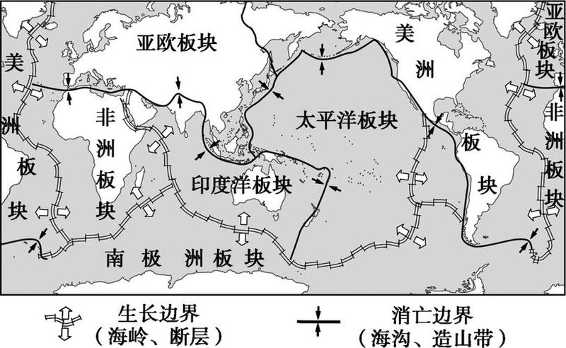
The 2020 senior geographic review: the first and most recent example from the british bbc reported that a number of international scientists had claimed that a new continent called “cessian” had been found around new zealand and might become the eighth continent in the world. According to scientists, 94 per cent of the continent, located in the south-western pacific ocean, is immersed on a shallow continental shelf, with a large surface and only a few areas emerging from the sea, including well-known new zealand. So finish the 1-2. 1. New zealand is located at the interface between the indian ocean and pacific plates (( )1 and the pacific ocean plates 2 pacific and antarctic plates 4-growth boundary 4-destroyed boundary a. 13 b. 14 c. 23 d. 242. The earth's rock collages consist of different plates that can be divided into continental and oceanic plates. The following areas are of the same type as “siland” () the sea of japan 2 sumatra 3 iceland 4 hawaiian islands a. 12b. 34 c. 23d. 14 dialysis: question 1, new zealand lies at the border between the indian ocean and pacific plates, and the two plates are crushed by collisions and fall within the border of extinction. Question 2, according to the title information, “cessierland” is a continent located in the south-western pacific ocean, 94 per cent of which is immersed in seawater, with surface rises and volatility, with only a few areas emerging from the sea, including well-known new zealand. It is explained that “cesian” is a land plate, mostly below sea level. The islands of japan and sumatra are all part of the eurasia plate. Answer: 1. B 2. A. Ii. The tectonics of the plate 1. The tectonics of the plate are not part of a whole, but are divided into six large plates with fractured bands (ridges, trenches, etc.); these are “floating” above the flotosphere, moving unstoppably; the interior of the plate is more stable and the boundary is more active in the crust. 2. The direction of the movement of the continental plate in the zone of collision between the continental plate of the plate and the continental plate of the boundary with the ocean plate in the category of motion boundary classification plate-type the coastal mountains that form the geomorphological crack valleys, oceans, high seamounts, trenches, island arcs such as the east african rift valley, the red sea, the atlantic ocean and the himalayas, the alps and the rockies, the pacific western arc, the trench iii, and the master training chart 3 represent a map of the distribution of different layers at a certain level (the layers represented by aha-h are old to new). Read the diagram and finish the 1-2. Figure 31. The geological formation of the graph area is () a. Slant c. C. Wrinkled b. Fragmentation d. Four geological profiles in figure 4 and corresponding to the a-b state of the ale-b. Question 2, old, new with two wings in the middle of the upper rock formation in the direction of horizontal a, is tilted back and very close to the bottom at the largest bend of the substrate; the second horizontal direction is the middle of the upper rock formation, the new, the two wings are older, and it is tilted. This is the correct option. Figure 5 shows the geological profile of an area. Read the diagram, finish 3-4. Figure 53. As to the determination of the sequence of formation of the rock formation, it is correct that () a. A. Formed before b. C. Before b., at the earliest, d. D. D. D., at the latest, formed before b. A., at the same geological formation as b., which may contain a rich hydrocarbon resource, c. Rock fragmentation, is similar to that of d., which is currently mainly affected by external forces. Unknown rock formations are early and late: prior to c, b or later, it is impossible to judge because of the lack of interface between the two formations. Question 4, reading the figure, is that two points are tilted, one is not, and one is wrong, a; the tilt is not oil and gas storage, b is error; the tilt rocks are not fragile, one is fractured, c is wrong; and the surface 12 is exposed and the external force is currently dominant, d is correct. In the summer, a geological expedition visited the gangnam hills region. In a survey along a-d in figure 6, it was found that a and d were identical and relatively new; b and c were identical but older. Accordingly, answer 5-6. Figure 65. During the mission, the best camp in the map was () a. 1 b. 2c. 3 d. 46. The following is the correct representation of the geological profile along a-d: () ab c d figure 7. B. 6. D, question 5. B. 6. D. The best camp is an open terrain and an appropriate slope, so b is correct. Question 6, which was examined along the a-d route, found that a and d were identical and relatively new; b and c were identical, but older, with a back slope. B. C, d above 250 m, 200 m, 350 m, a above 300 ~ 350 m. Pick d. The impact of this effect is particularly significant in areas of plains, where the side-line erosion of water leads to a gradual collapse and retreat of the river banks. Figure 8 illustrates the natural evolution of rivers in a flatland area. Accordingly, 7-9 issues were completed. Fig. 87. When the river flows through the curved river lanes, the dent's side erosion becomes more intense, mainly due to the fact that the ()a. On the side of the dent is large and fast. B. The rock layer is relatively loose and soft c. The slopes of the river bed, which is more inclined by the earth, are 8,