Summary of high school knowledge points on geo-water cycle
Contents
Toc\o "1-9"\zhyperlInk\l " toc256 million" directory 1
HyperlInk\l " toc2560001" text 1
HyperlInk\l " toc25600002" 1, type of water cycle 2
HyperlInk\l' toc25600003'2 meaning of the water cycle 2
HyperlInk\l " toc25600004"3 factors affecting the water cycle: 2
HyperlInk\l ' toc25600005'4 effects of human activity on the water cycle 3
HyperlInk\l ' toc25600006'5 main type of supply of river 4
HyperlInk\l' toc25600007'6's judgement on river supply type 4
HyperlInk\l " toc25600008" (1) by region of river 4
HyperlInk\l " toc25600009" (2) based on runoff process 4
HyperlInk\l ' toc256000010'7 recharging between rivers, lakes and groundwater 5
HyperlInk\l " toc256000011"9 analysis of the effects of human activities on the hydrological characteristics of rivers 10 5
HyperlInk\l' toc256000012'11 and the reading of the flow curve 6
HyperlInk\l ' toc256000013'12, common graphic analysis 7
HyperlThe southeast monsoon in august brought rain and rivers
HyperlInk\l " toc256000015" second quarter (summer); low winter temperature, 7
HyperlInk\l " toc256000016" second step to obtain information on the location of the river by graphic name or material 8
HyperlInk\l' toc256000017'13, interpretation of the submersible line 9
HyperlInk\l' toc256000018
HyperlInk\l" toc256000019"3
HyperlInk\l' toc256000020'4
Text
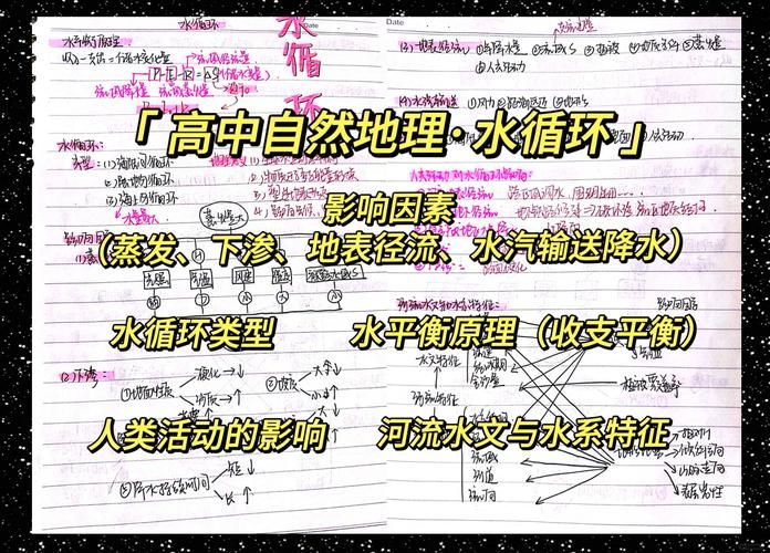
Summary of high school knowledge points on geo-water cycle
1. Types of water cycle
(a) inter-sea and land cycles: they occur between the oceans and the land, are the most important types and are also referred to as large cycles, supplementing and regenerating land water resources
Typical: the yangtze is involved in surface runoff of the water cycle; the summer wind is involved in the flow of water from the water cycle; the land cycle: it occurs on land and above land, with very small quantities of water refuelling land water
Typical: precipitation in the tarim river basin
Intra-sea cycle: occurring over and above the oceans and seas, with large precipitation
Typical: unlanded typhoons
2. Meaning of the water cycle
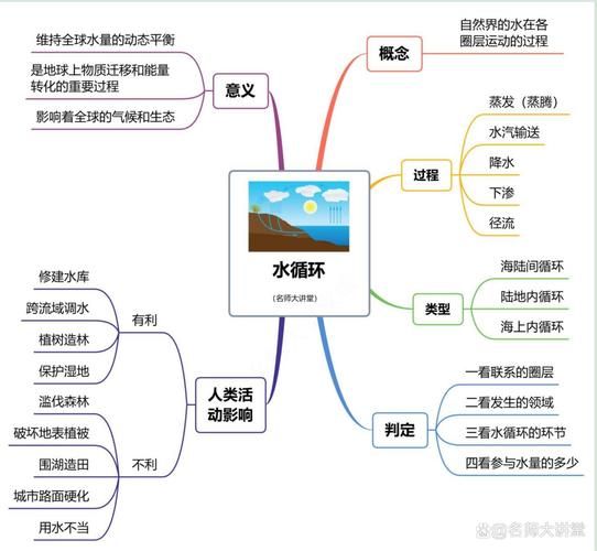
The significance of the water cycle: maintaining the dynamic balance of global water, keeping the global water bodies in a state of constant renewal; making physical transport and energy exchange between the various layers of the surface and between land and sea; affecting the global climate and ecology; shaping surface patterns
3. Factors affecting the water cycle:
Evaporation factors: light, temperature, wind speed, humidity, surface area of water
Factors affecting water vapour conveyor belts: wind (wind belts: bands, west bands, polar east bands; monsoons: mainly summer winds); proximity to the sea; obstruction of the terrain
E. Factors affecting precipitation: sufficient water vapour, intense atmospheric movement and the formation of precipitation by napalm
Factors affecting surface runoff: factors affecting seepage
Factors affecting surface runoff: consideration of surface runoff, down seepage, with a focus on the qast landscape: underground dissolved holes, large underground rivers, large stocks of groundwater
Impact of human activities on the water cycle
, positive impacts:
? Build reservoirs, change the seasonal distribution of surface runoff, reduce runoff during floods and increase runoff during dry runoff; and increase groundwater levels due to increased surface area and lower seepage, which can increase evaporation and precipitation。
? Inter-basin watering to change the spatial distribution of surface runoff can also increase evaporation and atmospheric water vapour, thereby increasing precipitation
? Afforestation, conservation of wetland resources, which supports water sources, increases down seepage and reduces surface runoff。
? Cities can reduce surface runoff, increase down seepage and increase underground runoff by laying seepage bricks。
? Implement artificial rainfall and increase precipitation。
Negative impact
Deforestation, which destroys surface vegetation, reduces evaporation, reduces water vapour in the air and reduces precipitation; when rainfall takes place, lower seepage occurs and large surface run-off flows converge and are prone to flooding. Lake-building fields reduce the natural water retention of lakes, reduce their flood-resistant and drought-resistant capacity, and reduce the effect of lake water bodies on climate regulation in surrounding areas。
Urban roads are hardened, surface runoff is increased, seepage is reduced, underground runoff is reduced and surface evaporation is reduced, which can lead to flooding within cities。
Over-inducing irrigation in upstream river areas can lead to reduced or even loss of downstream water
Over-exploitation and use of groundwater, resulting in a decrease in the groundwater table, could result in springs being released
Local stoppages; ecological degradation and land desertification in oases; coastal areas
This can lead to the infusion of water and salinization of land。
5. Main types of supply of rivers
6. Determination of the type of river supply
(1) based on the area where the river is located
Analysis of the thinking: a chart of the regional climate characterization arrow based on latitude or surface contour head
Type of river supply. For example, in the eastern monsoon region of the country, the rivers are predominantly rain-fed; north-west drought
The semi-arid zone is dominated by high-altitude ice-melted water supplies; rivers in the north-eastern region have springs and summers
During this period, spring sprouts are formed by seasonal snow smelting and summer sprouts by rain。
(2) based on run-off processes
Rivers, mainly rain-fed, with large variations in run-off flows, depending on rainfall
Change
Rivers, mainly glacial-melted water recharge, whose runoff varies with temperature and peaks in the summer
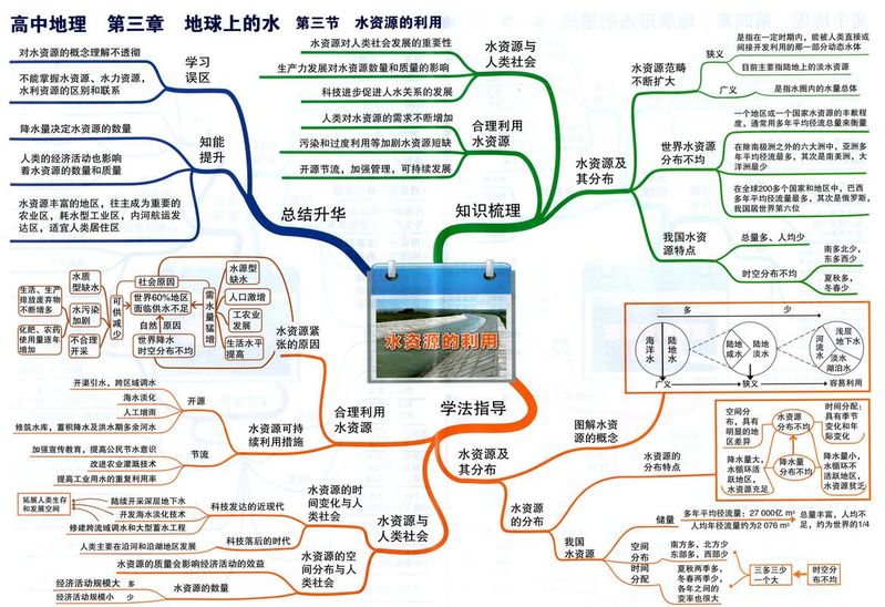
Rivers, mainly groundwater recharge, with smooth and reliable run-off
The lake regulates runoff, making runoff less variable
It is the seasonal snowstack that supplies the water。
7. Resupply of rivers, lakes and groundwater
River water, lake water, groundwater have a relationship between water sources, and when the river is above the surface of the lake or dive, the river recharges the lake or dives the river; when the river is below the surface of the lake or dive, the lake recharges the river. Rivers and lakes also contribute to river runoff
The effect is to accumulate part of the flooding during the flood period, which can slow down and reduce river peaks. During drying, lakes feed rivers and increase runoff downstream of lakes. Description of river hydrological characteristics and water system characteristics:
Hydrological characteristics include: river flow, sand content, chronology, ice-freeness, flow speed, type of recharge
Water system characteristics include: river length, flow, water system status and basin coverage, number of tributaries and their morphology, river network density, and so on, hydrological characterization and water system characterization
Analysis of the effects of human activities on the hydrological characteristics of rivers 10
Analysis of the effects of human activities on the hydrological characteristics of rivers,10 methods of determining the direction of rivers
The river flows into the valley, according to a contours, and it always flows from the top to the bottom, and from the valley to the top, the river flows in the opposite direction。
The river flows by land and sea
Because most rivers flow from land to the sea, so if there's land
With the ocean, the river flows. The river is north-west
The numerical size of the submersible line can reflect the high and low terrain, i. E., the large values of the submersible line indicate a higher terrain. The bending of the submersible line reflects the relationship between the river and the submersible, i. E., a permutation of any of the submersible lines, pointed from a numerically high point to a low point, if the permutation arrow points to the river, indicating that the submersible river is replenished, and vice versa。
, determine the flow of rivers based on the water table curves up and down of lakes or reservoirs
Lakes or reservoirs regulate river run-off, making annual run-off of rivers downstream of lakes or reservoirs more stable, so that the water table changes curves are less volatile。
11. Reading of river flow curves
. General cross-referenced coordinates indicate time changes, and even if the coordinates indicate temperature, flow
(a) the length of the river's run-off, the length of the run-off or the year of drying, the year of windfall, and the months in which the run-off occurs, the annual pattern of flows, the usual supplies (participating in the above table to complement the world-wide)
(1) floods occur in the summer autumn and in the drying water in the spring of winter, generally supplying rain, but in the mediterranean climate zone, rivers are the opposite。
(2) in the summer rivers, in addition to rainwater recharge, it may also be glacial water recharge (3) in the spring and summer rivers, and in addition to rainwater recharge, there may be seasonal snow harvesting。
(4) the loss of rivers during the winter may be due to the freezing of rivers, which often do not melt because of low temperatures, lack of glacial water recharge。
(5) the flow curve changes and slows, mostly in groundwater recharge, but also in rivers of tropical rainforest climate or temperate marine climate zones。
12. Common graphic analysis
, multiple supply modes of river flow curves (pines river)
In the northeast, due to the high latitudes, the winter is severe, and the winter is very cold
The snow is thick, the snow melts in spring and spring, april
On the left and on the left form the first tributary
The south-east monsoon in august brought rain and rivers
The second season (summer); low winter temperatures
River freeze。
Change of flow before and after the reservoir is built figure
The reservoirs have been able to absorb the volume of the river
Yes, we can save water during the season
Water level downstream of reservoir; during drying
It'll boost the reservoirs
Swim water levels, so that the river flows
The amount has been flattened to the point of eliminating the flood
The aim is either to delay the flood peak and to increase the amount of downstream water during the drying of the water in order to avoid harm。
, human lakes, flow curves from lakes figure
In the middle of the season, water flows upstream, partly into the lake
It reduces the amount of downstream water, so that the lake can go downstream
The water level was reduced during the season, and when it was dry
Some of the water in the lake can flow back to the river
Add the amount of downstream water, so that when it's dry, water
Bits up. Runoff processes downstream of lakes
It's smoother than upstream。
, run-off in different parts of the same river change
The first step in this mapping is to make it clear that changes in runoff are mainly influenced by climate (precipitation and temperature)。
Step two, obtain information on the location of the river by graph name or material
The type of river recharge is determined by obtaining information on the location of the river on the basis of a graphic name or material and analysing the factors influencing the change in runoff in relation to changes in time and runoff that occur in runoff high or low-value areas。
In the right picture, the river is located in the northern hemisphere. The low volume of water in the upper part of the river, the slow monthly changes in water volume, low winter run-off and large summer run-off suggest that run-off changes with temperature and that the type of supply should be ice-melted water. Changes in downstream run-off are evident throughout the year, with high winter run-off, low winter gas temperature, not a melted water supply, but only rainwater, and low downstream summer run-off, indicating low precipitation, which is well known in combination with downstream winter run-off and the mediterranean climate。
Elemental change curves associated with runoff figure
The figure below shows the cumulative monthly flow of a given river in our country, which is interpreted to clarify the relationship between the cumulative monthly flow of runoff and the flow of runoff, and the greater the monthly runoff, the greater the change in the cumulative runoff curve. The most notable variation in the june-september curve is illustrated by the fact that the june-september runoff is highest, as the river is known to be located in our country, with a large precipitation volume and a type of recharge。
13, interpretation of the submersible map
The submersible line map is the altimeter map of the submersible surface, which is based on the high and low water levels at various points on the submersible surface. In general, topographical maps are drawn in a manner similar to that used for contours. 1. Determination of the depth of the dive at a certain point
The depth of the dive is the vertical distance between the surface and the surface, which is equal to the altitude of the surface at that point minus the altitude of the surface at that point。
2. Determination of dive direction
The flow of surface and groundwater is vertically altimeters, from high to low; groundwater is permeable from the height of the dive。
3. Determination of the size of the current speed
The speed of the dive stream depends on the slope of the dive surface, the greater the slope, the faster the flow. On the same map, the greater the slope, the faster the dive line becomes。
4. Determination of the relationship between dive and water supply
When the water level of the river is higher than the dive level, the river recharges the diving level, and when the water level of the river is lower than the dive level, the river recharges the water. As shown in the figure below, a dive is used to resupply river water,b a dive to resupply river water。
The “summary of knowledge points of the high school geo-water cycle” document is web-based and is self-edited. Based on the principle of protection of authors ' intellectual property rights, it is only for learning exchanges and is not permitted to commercialize. If the author's rights are violated, please leave a message or send a message to contact him, and i will delete it as soon as possible. Thank you for reading and downloading